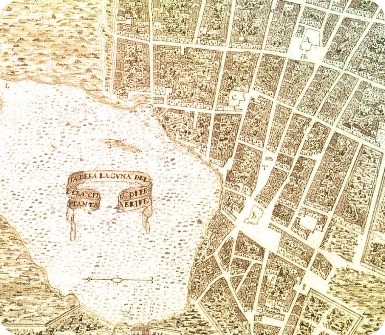
In 1588, Italian engineer Leonardo Torriani drew up the first map of the city, at least the oldest one that has been preserved. What we now know as the historic centre, as can be seen on this map, had already been defined at that time: the small cluster of disorderly houses to the west of La Concepción; the geometric layout to the east, stretching from this church to Villa de Abajo via three main streets, Herradores, Obispo Rey Redondo and San Agustín; the magical triangle formed by these streets, with Nava and Grimón and the Plaza del Adelantado as its corners… The Laguna that can be seen today is the same one that the Adelantado imagined when he looked out over the valley from the nearby hills.

As buildings and squares were erected, following this checkerboard principle, the first unfortified colonial city, a city-territory, began to emerge from the vegetation. Why build walls when the surrounding mountains already protect the city? The privileged location of La Laguna, in a valley five hundred metres above sea level, made possible the birth of a new concept of settlement, a model that would henceforth also be applied in many colonial enclaves in the New World.

The development of the city revolved around the figure of its ruler. From its new location in what was known as Villa de Abajo, another street plan began to take shape, based on the prevailing planning style of the time: the hippodamian or grid layout.

Este plano registra el trazado de una ciudad del siglo XVI con la configuración de las calles del centro histórico de La Laguna, que quedó definida en esa época y apenas ha sido modificada desde entonces. Buildings have been lost along the way, new ones have appeared and some have been remodelled, but the skeleton of the city, its streets and corners, remains.

The layout of the blocks on the ground can be seen from a bird’s eye view. The town is divided into two parts: Villa de Arriba, on the eastern side starting from the Church of La Concepción, and Villa de Abajo, to the south from that same point. For the first, the site of the founding settlement, no urban planning was carried out. There, Alonso Fernández de Lugo, the officer of the Crown of Castile who was given licence to conquer, explore and govern the island of Tenerife, established his first residence. Shortly afterwards, he would make a decision that would forever change the urban destiny of La Laguna: to move his home to another spot on the fertile plain he had discovered.

The Torriani Plan

Historical Overview

World Heritage City (UNESCO)

Notable buildings in the historic complex