Throughout the 16th century, the town developed into two distinct population centres, which emerged in different ways. The first settlement chosen by the Adelantado, around the Parish Church of Nuestra Señora de la Concepción, was characterised by its lack of a planned urban layout. It consisted of just a few stone houses with thatched roofs, which formed a small hamlet. Around 1500, a second, more rationalised settlement emerged, promoting the settlement of the population in the south of the territory, starting from Santo Espíritu (Convent of San Agustín).
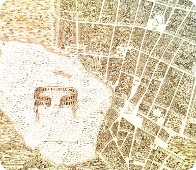
The two villages, La Villa Veccia or Villa de Arriba and Villa de Abajo, eventually merged. A new city was founded, based on Renaissance concepts using mathematical formulas, and its streets were laid out using navigational instruments. A grid-like urban system, formed by straight streets that make up blocks. Its layout is the first example of a non-fortified city, an example of a City of Peace, a city-territory that used its own natural borders to delimit itself: the Barranco de Chamarta and Barranco de las Carnicerías or Gonzalianes ravines, as well as the lagoon itself and the mountains that surround it, were its natural defensive systems. As an inland city on the island, it was also protected from the constant pirate attacks that threatened the Canary Islands’ coastline. This model would later be exported to American cities.
In the Villa de Abajo, built in the Castilian style, stands the main square, around which are located the houses of the Adelantado, the Justice and the Government of the Island. Queen Juana I of Castile issued a Royal Decree on 3 February 1510, granting the town its title and coat of arms. This coat of arms features the Archangel Saint Michael with military attributes; below the saint, the castle and rampant lion of the kingdoms of Castile and León, guarding a flaming mountain representing El Teide, surrounded by the sea. The coat of arms is completed by the inscription: MichaelArcángel beni in aditorium populo dey Tenerife me fecit, segung.
Throughout the century, urban growth occurred rapidly, to the point that in 1588, military engineer Leonardo Torriani, sent to the islands by Philip II to improve their defences and describe them, drew a map of Villa de La Laguna, which already showed three convents, six chapels, the Cabildo, churches, two hospitals, squares and streets, which can still be seen today. The description refers to it as the largest city built after the Conquest. The rapid growth of the town led Charles I to grant it the title of City on 20 January 1531 as well as that of Noble and Loyal History on 8 September 1534.